The Stone Mounds of Upper Mesopotamia: How Göbekli Tepe Proved Hunter-Gatherers Settled Down
- Bryan White

- Feb 28
- 23 min read
Introduction to a Prehistoric Paradigm Shift in Hunter-Gatherer Society
For the better part of a century, the standard narrative of human prehistory—often encapsulated by the concept of the Neolithic Revolution—posited a strict, linear progression of societal evolution. This model dictated that the advent of agriculture and the domestication of plants and animals were the absolute prerequisites for permanent human settlement. Only after securing a stable, surplus-yielding agricultural base, the theory argued, could human societies develop the social stratification, specialized labor, and population density required to construct monumental architecture and complex urban centers.1 This foundational paradigm has been systematically dismantled by the ongoing archaeological excavations at Göbekli Tepe, a site situated approximately fifteen kilometers northeast of the modern metropolis of Şanlıurfa in southeastern Turkey.2
Occupied during the Pre-Pottery Neolithic A and early Pre-Pottery Neolithic B periods, spanning roughly 9500 to 8000 BCE, Göbekli Tepe represents an architectural and cultural phenomenon that fundamentally contradicts traditional chronological models of human development.1 The site predates the invention of writing, the wheel, metallurgy, and the verified domestication of staple crops and livestock by millennia, yet it features the oldest known monumental megalithic architecture in the archaeological record.1
Initially interpreted in the late twentieth century as an isolated, anomalous sanctuary constructed by highly motivated, nomadic hunter-gatherers, the site was widely popularized as the world's "first temple".1 However, as excavations have progressed into the mid-2020s, integrating advanced geoarchaeological, archaeobotanical, and remote sensing technologies, a profound re-evaluation of the site has occurred.3 Göbekli Tepe is no longer viewed as a solitary anomaly devoid of domestic life. Rather, it is now understood to be a vibrant, permanent settlement, functioning as a central node within a vast, interconnected Neolithic cultural landscape known as the Taş Tepeler, or "Stone Mounds".7 This comprehensive analysis will explore the stratigraphic evolution, geometric sophistication, subsistence strategies, and shifting cognitive frameworks of the early Holocene communities that engineered this monumental landscape, ultimately redefining our understanding of the transition to sedentism.
The Historiography of Discovery and Excavation
The physical prominence of Göbekli Tepe, a massive artificial mound or tell situated at the highest point of the barren Germuş mountain range, did not entirely escape early archaeological notice.2 The site was first documented in 1963 during a joint surface survey conducted by the Universities of Istanbul and Chicago, led by archaeologists Halet Çambel and Robert Braidwood.2 The survey team observed numerous flint artifacts and large, regularly shaped limestone blocks littering the surface.2 However, constrained by the archaeological paradigms of the era, the team misinterpreted the massive limestone outcrops as the remnants of a Byzantine or medieval cemetery, failing to recognize the profound antiquity of the lithic scatters.4
The site's true significance remained obscured until 1994, when German archaeologist Klaus Schmidt, who had previously worked at the nearby Pre-Pottery Neolithic site of Nevalı Çori, visited Göbekli Tepe during a tour of southeastern Turkish Neolithic sites.2 Guided by local landowners who had unearthed unusual stones while plowing, Schmidt immediately recognized the morphological similarities between the surface finds at Göbekli Tepe and the prehistoric megaliths of Nevalı Çori.11
Formal excavations commenced in 1995 as a collaborative effort between the Şanlıurfa Museum and the German Archaeological Institute, under Schmidt's direction.2 These excavations rapidly revealed a completely artificial mound measuring fifteen meters in height and covering approximately nine hectares, concealing an intricate complex of circular enclosures defined by massive T-shaped limestone pillars.2 Following Schmidt's death in 2014, the directorship transitioned through several phases, eventually passing to Necmi Karul of Istanbul University in 2020, with Lee Clare serving as the coordinator for the German Archaeological Institute.2
By 2021, the site was integrated into the broader Şanlıurfa Neolithic Research Project, expanding the scope of investigation to encompass the entire region.7 Despite decades of continuous, intensive fieldwork, ground-penetrating radar and geomagnetic surveys indicate that less than five percent of the site has been fully excavated, suggesting that the vast majority of Göbekli Tepe's monumental structures remain sealed beneath the earth.11 Recent 2025 and 2026 excavation seasons have continued to yield extraordinary discoveries, including clearly defined human statues and extensive domestic structures mapped via subsurface scanning on the mound's eastern and southern slopes, continually reshaping the interpretation of the site's primary function.5
Stratigraphy and Architectural Evolution
The architectural sequence of Göbekli Tepe is highly stratified and presents a fascinating inversion of typical developmental models. Rather than beginning with modest structures that grew in scale and complexity over time, the site's most monumental and labor-intensive architecture is found in its oldest stratigraphic layers, indicating a peak in megalithic ambition that gradually transitioned into smaller, more functional designs over subsequent millennia.
Stratigraphic Level | Chronological Period | Architectural and Structural Characteristics | Distinctive Megalithic Features |
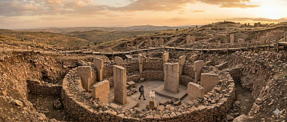
Level III | Pre-Pottery Neolithic A to Early Pre-Pottery Neolithic B (circa 9500 BCE) | Massive circular to oval enclosures ranging from 10 to 30 meters in diameter. Structures feature at least two concentric walls.3 | Bilaterally symmetrical arrangements of massive T-shaped limestone pillars. Central pillars reach heights of up to 5.5 meters and weigh between 10 and 22 metric tons. Pillars are set into bedrock-carved pedestals and feature elaborate animal high-reliefs.4 |
Level IIA | Middle Pre-Pottery Neolithic B (circa 7500 BCE) | Smaller, sub-rectangular to rectangular buildings measuring approximately 5 by 3 meters. Features finely executed terrazzo floors made of burnt lime.3 | Pillars are significantly smaller, ranging from 1.4 to 2 meters in height, and are largely undecorated. Structures often include stone benches or buttress-like wall projections instead of monolithic rings.6 |
Level IIB | Intermediary Phase (Late PPNB transition) | Characterized by unassuming ovoid structures that blend into typical domestic architectural traditions of the broader region.6 | General absence of monolithic T-pillars; architecture suggests a shift away from specialized megalithic display toward standard residential utility.6 |
The Level III enclosures, particularly Enclosures A, B, C, and D, are the defining features of the site. The T-shaped pillars are generally understood to be highly stylized anthropomorphic figures.16 While the peripheral pillars incorporated into the enclosure walls often feature intricate low-relief carvings of varied wildlife, the towering central pillars are distinctly human, featuring carved arms descending the sides of the stone, hands resting on the abdomen, and detailed depictions of belts and loincloths.12 Most of the pillars exhibit small cupmarks or depressions on their top surfaces, likely remnants of the quarrying and shaping process utilizing flint tools.6 Furthermore, several Level III buildings feature monumental stone entranceways, or "U stones," typically oriented toward the south or southeast, dictating a specific flow of movement into the enclosures.6
Geometric Sophistication and the Master Plan
The complexity of the Level III enclosures extends far beyond their sheer size. For many years, archaeologists debated whether the circular enclosures grew organically—with pillars added haphazardly over generations—or whether they were the result of a unified, preconceived design. Advanced architectural formal analysis and spatial mapping have provided compelling evidence for the latter, demonstrating a level of geometric planning previously considered impossible for non-agricultural societies.
Researchers utilizing standard deviation mapping algorithms analyzed the precise locations of the pillars and peripheral walls across the main excavation area.12 By mapping thirty-two evenly spaced points at one-meter intervals along the curvature of the inner face of the peripheral wall in Enclosure C, the algorithm identified a perfect statistical center point.12 This center point is located exactly at the midpoint between the southern faces of the two massive central pillars.12
From this central node, strict geometric equidistance rules were applied by the Neolithic builders. Along the main structural axis, the distance from the center point to the inner faces of the central pillars is approximately 2.8 meters.12 Remarkably, this exact distance is mirrored from the inner faces of the central pillars to the inner face of the peripheral wall.12 This consistent application of an abstract geometric rule—where the edges of the pillars, rather than their mass centers, dictate the alignment—indicates a highly sophisticated understanding of spatial hierarchy.12
Furthermore, spatial analysis suggests that Enclosures B, C, and D are not isolated structures built sequentially, but rather a single, integrated architectural complex governed by an underlying equilateral triangular pattern.12 The central pillars of Enclosures B and C align perfectly along an axis parallel to the southern side of this theoretical triangle.12 This overarching design indicates that the builders referenced specific, abstract points in space to lay out multiple enclosures simultaneously, a process that reflects a "quantic jump" in architectural planning.12 The precision of the stonework, combined with these rigid geometric laws, strongly suggests the existence of a "school of specialists" who possessed formalized architectural knowledge and directed the massive labor forces required for construction.12 This same abstract geometric rule involving pillar edges aligning with main axes has been observed in the Pre-Pottery Neolithic B rectangular cult building at Nevalı Çori, indicating that this architectural tradition endured and evolved over thousands of years.12
The Logistical Mechanics of Megalithic Construction and Social Cohesion
The realization that Enclosures B, C, and D were likely planned and constructed as a unified project exponentially increases the estimated labor and organizational requirements for Göbekli Tepe.12 The central pillars, measuring up to 5.5 meters in height, possess estimated masses ranging from 10 to 22 metric tons.4 The limestone was quarried directly from the bedrock plateau adjacent to the site.6 Excavators have identified U-shaped vertical channels cut into the bedrock with flint tools, which were used to isolate the massive blocks before wooden levers and wedges were employed to split the limestone free.6
Once freed, these monoliths had to be transported across distances ranging from 100 to 500 meters, over uneven and generally upward-sloping terrain, without the aid of wheeled carts or draft animals.4 Experimental archaeology and ethnographic analogies provide vital context for this undertaking. Historical accounts of megalith builders on the Indonesian island of Nias describe 525 individuals hauling a similar-sized monolith over three kilometers in three days to construct a grave.18 While the exact manpower requirements for Göbekli Tepe remain an estimate, it is clear that moving the stones required hundreds of highly coordinated individuals working in unison.4
The fundamental anthropological question raised by Göbekli Tepe is how a society of "low-hierarchical" hunter-gatherers generated and maintained the social cohesion necessary for such a massive communal project.18 In agrarian, state-level societies, monumental construction is typically achieved through centralized, coercive authority and the taxation of agricultural surplus.1 In the Pre-Pottery Neolithic, however, alternative mechanisms for mobilization were required.
Archaeological evidence strongly points to the "work feast" hypothesis.18 Ethnographic studies demonstrate that communal feasts are a primary mechanism for building social bonds, exchanging information, and securing marriage partners among dispersed hunter-gatherer bands.18 To attract the massive labor force necessary to quarry and move the pillars, local leaders or community groups likely hosted spectacular feasts.18 This theory is heavily supported by the material record at Göbekli Tepe, which includes enormous stone vessels capable of holding up to 160 liters of liquid—potentially early forms of fermented beverages—and massive middens containing tens of thousands of processed animal bones.10 In this model, the construction of the monuments was not the product of a despotic ruling class, but rather a cooperative endeavor fueled by intense, resource-heavy social gatherings that temporarily bound disparate nomadic groups into a unified labor force.18
The Sanctuary Versus Settlement Paradigm
For the first two decades of its excavation, the interpretation of Göbekli Tepe was dominated by a specific paradigm championed by Klaus Schmidt: the "temple hypothesis".1 Schmidt argued that the monumental structures were exclusively ceremonial centers, devoid of any domestic habitation.1 He pointed to the lack of standard residential buildings, the absence of hearths, and the perceived lack of typical domestic refuse in the early excavation trenches, concluding that the site was a "central cult center" consisting of "pristine temples" visited by nomadic pilgrims.1 Under this theory, the enclosures were interpreted as unroofed, open-air sanctuaries, structurally unsuitable for habitation.6
However, as excavation methodologies evolved and the investigated area expanded, a robust counter-narrative emerged, led by archaeologists such as E.B. Banning.6 Banning criticized the temple hypothesis for relying on a modern, ethnocentric dichotomy that artificially separates "sacred" spaces from "profane" domestic spaces.6 Anthropological evidence suggests that in Early Neolithic cosmologies, everyday life and residential architecture were inherently infused with profound spiritual and symbolic meaning.6
Banning drew critical comparisons to other Pre-Pottery Neolithic sites across the Near East to illustrate this point. At Çatalhöyük, buildings initially identified as dedicated "shrines" due to their elaborate wall paintings and bull-horn installations were subsequently proven, through micro-stratigraphic analysis, to contain abundant evidence of ordinary domestic activities, including food preparation, tool maintenance, and sleeping.6 Similarly, at sites like Jerf al-Ahmar, Hallan Çemi, and Cafer Höyük, highly symbolic items such as aurochs skulls, cattle horns, and elaborate stelae were routinely incorporated directly into the walls and benches of standard residential houses.6 The special status of the famous "cult building III" at Nevalı Çori relies entirely on contrasting it with surrounding domestic structures; Banning argued that the enclosures at Göbekli Tepe share striking similarities with this building and could represent an exaggerated form of the same domestic-symbolic tradition.6
The archaeological record at Göbekli Tepe itself has increasingly contradicted the pure sanctuary model. The site contains enormous amounts of debris related to domestic and construction activities, including large tools typically associated with food processing and serving.6 The increasing frequency of glossed sickle blades—tools specifically used for cutting silica-rich plant stems, indicative of intense wild grass harvesting or incipient cultivation—further points to a settled population engaged in continuous subsistence activities.1
The debate has been largely settled by the findings of the 2024, 2025, and 2026 excavation seasons. Extensive ground-penetrating radar surveys across the eastern and southern slopes of the mound have conclusively detected a vast array of smaller, non-monumental structures interpreted as early domestic buildings, existing alongside the massive circular enclosures.5 Furthermore, evidence of large, stone-cut cisterns for water management, alongside extensive grain-processing tools and hearth features, indicates a fully-fledged settlement with permanent occupation.1 Consequently, the current academic consensus recognizes Göbekli Tepe not as an empty cathedral, but as a bustling, permanent Neolithic village where monumental symbolic architecture was intimately intertwined with the daily lives of its inhabitants.1
Archaeozoological Profiles and Subsistence Strategies
To sustain a permanent or semi-permanent settlement capable of monumental construction, the inhabitants of Göbekli Tepe required a robust and highly organized subsistence strategy. The environmental context during the site's primary occupation around 9500 to 8000 BCE—the early Boreal period, following the Younger Dryas stadial—was significantly different from the arid landscape of modern Şanlıurfa.6 Paleoecological proxies indicate a considerably more humid climate with denser steppe-forest vegetation, a higher regional water table, and the likely presence of local springs that have since dried up.6
This rich ecosystem supported diverse wildlife, which formed the absolute basis of the site's animal economy. An exhaustive archaeozoological analysis comprising over 38,000 identified mammalian bone fragments reveals a pronounced reliance on the hunting of wild game, effectively precluding the presence of domesticated livestock during the site's earliest phases.23
Identified Mammalian Species | Specimen Count (NISP) | Dietary Significance and Meat Yield Analysis |
Goitered Gazelle (Gazella subgutturosa) | 7,949 | The most frequently hunted animal by absolute count. However, due to their relatively small body mass, intra-species bone weight analysis indicates gazelle contributed only approximately 15 percent of the total meat consumed at the site. Hunting likely occurred in massive pulses between midsummer and autumn.19 |
Aurochs (Bos primigenius) | 2,574 | Though fewer in number than the gazelle, the massive size of these wild bovines meant they provided the bulk of the community's animal protein, contributing an estimated 50 percent of the total meat consumed, forming the centerpieces of communal feasts.24 |
Mouflon / Wild Sheep (Ovis orientalis) | 1,237 | A major target for hunters. Morphometric analysis and demographic profiling strictly confirm these were morphologically wild populations, not managed herds.24 |
Asiatic Wild Ass (Equus hemionus) | 1,177 | A significant secondary source of protein extracted from the surrounding open steppe environments.25 |
Wild Boar (Sus scrofa) | 863 | Hunted frequently, likely utilizing the denser gallery forests near local water sources and river valleys.25 |
Small Mammals, Birds, Fish | Varied (e.g., Cape Hare: 386) | While fowling and fishing occurred, the generally low frequency of remains—even in sieved archaeological contexts—indicates a modest contribution compared to large ungulates.24 |
The demographic profiles of the archaeofaunal assemblages provide critical insights into the nature of the society's relationship with animals. The populations of founder herd species (wild sheep, pigs, and cattle) are overwhelmingly dominated by adult animals rather than sub-adults, and remains of males significantly outnumber females.24 This specific demographic signature is indicative of targeted hunting strategies rather than early animal husbandry or herd management, which typically results in the culling of young males and the retention of adult females.24 The lack of identified storage facilities at Göbekli Tepe suggests that the massive influxes of meat from seasonal gazelle hunts were processed for immediate consumption during large-scale communal work feasts, further cementing the link between subsistence success and monumental construction.19
Archaeobotany and the Protracted Transition to Agriculture
The role of plant foods at Göbekli Tepe is central to understanding the Neolithic Revolution. The site is geographically situated within the "Fertile Crescent," a region where the natural distribution areas of the wild forms of einkorn wheat, emmer wheat, barley, and other Neolithic founder crops extensively overlap.19 In fact, modern DNA fingerprinting has pinpointed the transition of two specific wild wheat variants to their domesticated forms to this exact part of southeastern Turkey.19
However, the archaeobotanical data present a complex, protracted narrative of plant domestication that did not occur uniformly across the Near East. Systematic early plant use is well-documented at nearby sites such as Cafer Höyük, Çayönü, Hallan Çemi, and Körtik Tepe.19 While regions in the southern-central Levant demonstrate the common cultivation of wild cereal species during the Pre-Pottery Neolithic A, early plant-based subsistence in the eastern Fertile Crescent—including the region around Göbekli Tepe—appears to have focused on a broader, more diverse spectrum of wild resources, including legumes, goatgrass, fruits, and nuts.28
Despite this broader initial focus, there is unequivocal evidence for the intensive processing of wild cereals at Göbekli Tepe. Excavations have yielded thousands of massive basalt grinding stones.19 Furthermore, soil analyses reveal extraordinary concentrations of phytoliths—microscopic silica structures formed in plant tissues—ranging from 0.5 to 3.0 million phytoliths per gram of sediment within the enclosure fills.19 Morphometric analysis of elongate dendritic phytoliths from these samples indicates the heavy presence of Triticum monococcum (einkorn), Hordeum spontaneum (wild barley), and Hordeum vulgare (barley), confirming that vast quantities of these grasses were brought to the site.29
Crucially, the transition from the intense harvesting of wild stands to true biological domestication was slow. The available archaeobotanical evidence indicates that domesticated-type cereal chaff—which exhibits tough rachises that prevent natural seed dispersal—does not appear in significant proportions (greater than 10 percent) in this region until approximately 400 to 1,000 years after it first appeared in southern Syria.28 Therefore, the builders of the Level III enclosures at Göbekli Tepe were highly sophisticated foragers engaging in pre-agricultural plant management. Their intensive processing of wild cereals sustained the community and funded the feasting economy long before formal agriculture was adopted.19
The Taş Tepeler Regional Network and Iconographic Evolution
Perhaps the most transformative development in the study of the Neolithic Near East in recent years has been the contextualization of Göbekli Tepe within a broader cultural landscape. Initiated in 2021, the Şanlıurfa Neolithic Research Project has unified archaeological and scientific data across a 200-kilometer expanse, revealing that Göbekli Tepe is merely one of at least twelve contemporaneous settlements collectively known as Taş Tepeler.7
These sites, dating from approximately 10,000 to 7,000 BCE, exhibit an advanced level of shared consciousness in belief systems, social organization, and cultural production.7 While they share the foundational architectural tradition of T-shaped pillars, a comparative analysis reveals highly localized adaptations and a profound evolution in iconographic expression over a 1,500-year period.17
Taş Tepeler Site | Approximate Location | Key Archaeological Features, Architecture, and Iconography |
Göbekli Tepe | 15 km NE of Şanlıurfa | Defined by massive, surface-built circular enclosures and giant T-pillars. The iconography is overwhelmingly dominated by zoomorphic imagery, often depicting aggressive or threatening animals (scorpions, snakes, spiders, foxes, vultures). Human figures are highly abstract and faceless.6 |
Karahantepe | 60 km from Şanlıurfa | Architecture is frequently carved directly into the bedrock, creating subterranean spaces. Features the "Pillar Pit," a sunken ritual chamber containing eleven phallic stone pillars. Iconography marks a dramatic shift toward realistic human imagery, including the "Ribbed Man" and a massive 2.3-meter-tall human statue featuring a v-neck motif, detailed facial hair, and a shaved head design.31 |
Sayburç | Near Çakmaktepe | Features deep, rock-hewn circular communal structures (up to 12 meters in diameter) with seating benches. World-renowned for the "Sayburç Reliefs," a 3.7-meter-long continuous visual narrative carved into the wall. Depicts five interacting figures: a central human holding his phallus flanked by leopards, and another human holding a snake/rattle facing a bull.34 |
Sefertepe | 10 km from Karahantepe | Characterized by a distinct local sculptural idiom. Discoveries include 12,000-year-old carved human faces in both high and low relief on neatly dressed stone blocks, alongside portable art such as a double-sided human motif carved into a polished serpentinite bead.31 |
Kurt Tepesi | Shadow of Göbekli Tepe | Features subterranean enclosures and T-shaped pillars. Represents a crucial transitional phase bridging the gap between mobile forager camps and settled, symbolically complex communities.31 |
Other Network Sites | Varies across the region | Includes Harbetsuvan Tepesi, Gürcütepe, Taşlıtepe, Ayanlar, Yoğunburç, Çakmaktepe, and Yenimahalle, all contributing to a vast network of interaction and shared material culture.9 |
The iconographic evolution across the Taş Tepeler landscape is critical for understanding the psychological transition from foraging to farming. At Göbekli Tepe, the prominence of fearsome, venomous, and scavenging animals, coupled with the abstract, faceless nature of the anthropomorphic pillars, suggests a worldview wherein humanity perceived itself as merely one component of a dangerous, untamed natural ecosystem.16 Humans were observers and participants, but not necessarily masters, of the wild.32
However, sites that reached their zenith slightly later—such as Karahantepe, Sayburç, and Sefertepe—demonstrate a radical cognitive shift. The artistic focus transitions aggressively toward the human form.32 The emergence of three-dimensional, realistic facial carvings, explicit phallic symbolism celebrating human virility, and narrative scenes depicting humans actively engaging with or subduing dangerous animals (as seen in the Sayburç reliefs) reflects a fundamental change in self-perception.17 Humanity was beginning to conceptualize itself as distinct from, and dominant over, the natural environment.7
This anthropocentric worldview is a necessary cognitive prerequisite for the domestication of plants and animals; one must first believe they possess the authority to control nature before attempting to physically alter the genetics of wheat or corral wild sheep. Furthermore, the continuous narrative reliefs at Sayburç, carved into spaces designed for communal seating, strongly suggest that these enclosures functioned as prehistoric theaters for oral storytelling.34 In the absence of written language, these stones served as visual carriers of collective memory, broadcasting shared myths and social norms that ensured cultural continuity across generations.34
Geoarchaeology, Ruin Interaction, and the Abandonment Mystery
A central enigma of Göbekli Tepe has been the nature of its eventual abandonment around 8000 BCE. For many years, the prevailing hypothesis advanced by the initial excavation team proposed a scenario of intentional, ritualistic backfilling.3 This theory posited that after an enclosure had served its purpose, the community undertook the staggering task of deliberately burying it under thousands of cubic meters of limestone rubble, animal bones, and earth.10 The ostensibly homogenous nature of the fill within the enclosures was cited as primary evidence for this intentional human action.20
However, sophisticated geoarchaeological analyses, pedological studies, and structural assessments conducted over the last decade have comprehensively debunked the intentional burial hypothesis.3 The "fill" is now understood to be the result of catastrophic natural forces rather than religious decree. The monumental special buildings, situated on the lower slopes of the tell, were repeatedly inundated by massive, destructive slope slides.3
These severe landslide events were likely triggered by a combination of intense regional seismic activity and periods of exceptionally heavy winter rainfall, which washed enormous volumes of debris—including middens, domestic refuse, and rubble from superstructures located higher up the slopes—down into the lower enclosures.39 Crucial evidence supporting this slope-slide hypothesis includes localized structural damage to the architecture, the presence of distinct air pockets trapped within the rubble matrix, and the discovery of negative impressions of collapsed wooden roof beams within the fill.39 During Building Phase 5, the inhabitants attempted to mitigate these disasters by erecting heavy terrace walls, but these measures ultimately failed when a subsequent massive landslide precipitated the final abandonment of the enclosures in Building Phase 6.3
The realization that the site was subjected to repeated natural destruction has led to the development of the "ruin interaction" framework.40 The Neolithic inhabitants did not simply abandon their damaged temples. Instead, they exhibited extraordinary social resilience, repairing structures over hundreds of years and utilizing the ruins as dynamic interaction spheres.40 The community actively mined the collapsed enclosures for raw materials, extracting pillar fragments, heavily worn grinding stones, and dressed wall blocks to construct new, smaller rectangular structures in the upper stratigraphic layers.40
This continuous cycle of destruction, extraction, and re-production transformed the site into a massive "memory space," where the physical remnants of the past were literally built into the foundations of the present.40 Consequently, Göbekli Tepe was not suddenly and mysteriously abandoned; it underwent a gradual, centuries-long decline as the sheer environmental pressure of repeated landslides, combined with the shifting socio-economic realities of the encroaching agricultural revolution, made the maintenance of the megaliths untenable.3 This concept of ruin interaction extends into the modern era; contemporary archaeological excavations, conservation infrastructure, and tourism have created a distinct "Anthropocene horizon" at the site, representing the latest layer of human intrusion into the stratigraphy.40
The Archaeoastronomy Debate: Constellations and Cataclysms
The profound antiquity, complex iconography, and precise geometric alignments of Göbekli Tepe have inevitably generated alternative theories regarding its fundamental purpose, most notably the assertion that the site functioned as an advanced astronomical observatory designed to record a global cataclysm.1
This hypothesis, primarily advanced by researchers Martin Sweatman and Dimitrios Tsikritsis, focuses heavily on the low-relief carvings of Pillar 43, often referred to as the "Vulture Stone," located in Enclosure D.41 Sweatman and Tsikritsis argue that the specific animal motifs on the pillar correlate directly with star asterisms and constellations as they would have appeared in the night sky thousands of years ago.41 By utilizing specialized astronomical software, they posit that the specific arrangement of symbols serves as a highly accurate date stamp corresponding to the year 10,950 BCE, with a margin of error of roughly 250 years.41
This specific date aligns closely with the onset of the Younger Dryas, a period of abrupt and severe global cooling that occurred at the end of the Pleistocene epoch.6 The researchers link this climatic anomaly to the controversial Younger Dryas impact hypothesis, suggesting that a devastating comet strike or an intense encounter with the Taurid meteor shower caused widespread environmental collapse and human mortality.41 Under this interpretative framework, Göbekli Tepe was constructed by the survivors of this cataclysm to commemorate the event, function as an observatory to monitor future meteor showers, and track celestial time using a sophisticated lunisolar calendar that incorporated eleven epagomenal days.41 Proponents of this theory argue that the headless human figure depicted at the bottom of Pillar 43 represents the massive loss of life resulting from the impact.42
While this archaeoastronomical theory has garnered substantial attention in popular media, it has been met with rigorous skepticism and formal academic rebuttals from the core archaeological team actively excavating the site.43 The primary critiques focus on fundamental discrepancies between the astronomical models and the physical realities of the archaeological record:
Chronological and Stratigraphic Inconsistencies: The proposed astronomical date of 10,950 BCE predates the earliest radiocarbon dates obtained from the wall plaster of Enclosure D by more than a millennium.42 While proponents counter that older, undiscovered phases of construction may exist, building sweeping astronomical theories upon unverified chronological assumptions remains methodologically unsound.
Architectural Context and Structural Viability: The celestial alignments proposed by the archaeoastronomy hypothesis inherently assume that the T-pillars currently stand in their precise original positions.45 However, building archaeology confirms that the enclosures underwent continuous modification; many pillars were recycled, moved, or re-erected over centuries of use.3 Furthermore, emerging evidence regarding roof structures—including the negative impressions of wooden beams—would have severely restricted the enclosures' utility as open-air celestial observatories.3
Selective Interpretation of Iconography: The archaeological team notes that mapping the site's diverse animal motifs onto modern Greek constellations requires a highly selective and subjective interpretation of the art.44 The site features a vast array of animals—including ducks, wild boars, spiders, and insects—that do not map easily onto celestial bodies.21 This suggests the imagery is more likely rooted in local mythology, earthly ecology, and regional animistic beliefs rather than serving as a literal celestial map.21
The prevailing academic consensus maintains that while the Neolithic populations of the Taş Tepeler region were undoubtedly highly observant of seasonal cycles and the night sky, interpreting Göbekli Tepe primarily as a precise astronomical observatory or a memorial to a comet impact stretches the available empirical evidence beyond its limits.43 Such theories, while compelling, often fail to account for the dynamic, messy, and highly localized realities of a functioning Neolithic settlement undergoing constant environmental stress, repair, and cultural repurposing.43
Conclusion
The ongoing investigation into the mysteries of Göbekli Tepe and the broader Taş Tepeler landscape serves as a profound testament to the dynamic, self-correcting nature of archaeological science. What began in the mid-1990s as the discovery of an anomalous, seemingly isolated "first temple" has matured into a comprehensive re-evaluation of human cognitive and social evolution.2
The empirical data now firmly establish that Göbekli Tepe was not a sterile, solitary sanctuary visited exclusively by nomadic pilgrims. It was, instead, a vibrant, permanent settlement featuring sophisticated domestic structures, advanced water management systems, and intensive food processing capabilities that blurred the lines between the sacred and the profane.1 Furthermore, the integration of the site into the expansive Taş Tepeler cultural network—alongside complex settlements like Karahantepe, Sayburç, and Sefertepe—demonstrates that the monumental architecture and rich symbolic world of the region were not a localized miracle, but a widespread, interconnected regional phenomenon.7
The evolution of the iconography across these sites maps the psychological journey of humanity during the early Holocene. Moving from the fearsome, abstract animal depictions of early Göbekli Tepe to the highly detailed, human-centric narrative reliefs of Sayburç and Karahantepe, the archaeological record captures the exact moment humanity began to view itself not merely as participants in nature, but as its masters.7 This cognitive shift laid the essential psychological groundwork for the subsequent domestication of plants and animals.7
By dismantling early myths—such as the intentional backfilling of the enclosures—in favor of evidence-based models like the slope-slide and ruin interaction hypotheses, researchers have restored agency and humanity to the builders.3 These early societies were not esoteric astronomers building monuments for unknowable celestial reasons; they were remarkably resilient communities fighting against extreme environmental pressures, utilizing massive communal feasts and shared oral storytelling to bind their society together and continually rebuild their world from the rubble of natural disasters.20
Ultimately, Göbekli Tepe does not rewrite history by suggesting that advanced, urbanized civilization existed prior to hunter-gatherers. Rather, it dramatically expands the boundaries of what highly organized, foraging societies were capable of achieving. It provides undeniable proof that the human drive to create monumental art, to organize complex social networks, and to etch collective memory into stone did not require the prerequisite of agricultural surplus. Instead, it was the very act of congregating to build these magnificent stone mounds that likely forged the complex social pathways necessary for the Neolithic Revolution to eventually flourish.
Works cited
Göbekli Tepe: The 12000-Year-Old Ruins That Rewrite the Story of Civilization, accessed February 28, 2026, https://www.openculture.com/2025/12/gobekli-tepe-12000-year-old-ruins-that-rewrite-the-story-of-civilization.html
FAQ – Tepe Telegrams, accessed February 28, 2026, https://www.dainst.blog/the-tepe-telegrams/faq/
Göbekli Tepe - Wikipedia, accessed February 28, 2026, https://en.wikipedia.org/wiki/G%C3%B6bekli_Tepe
Israeli Archaeologists Discover Hidden Geometric Patterns at Gobekli Tepe | Michael Peres, accessed February 28, 2026, https://blogs.timesofisrael.com/israeli-archaeologists-discover-hidden-geometric-patterns-at-gobekli-tepe/
News - Subsurface Scanning Detects Structures at World's Oldest Cult Center, accessed February 28, 2026, https://archaeology.org/news/2025/10/13/subsurface-scanning-detects-structures-at-worlds-oldest-cult-center/
So Fair a House : Göbekli Tepe and the Identification of Temples in the Pre-Pottery Neolithic of the Near East | Current Anthropology, accessed February 28, 2026, https://www.journals.uchicago.edu/doi/full/10.1086/661207
Taş Tepeler – The discovery of a Neolithic cultural landscape - DAI, accessed February 28, 2026, https://www.dainst.org/en/newsroom/tas-tepeler-die-entdeckung-einer-neolithischen-kulturlandschaft/792
Discovering a New Neolithic World - Archaeology Magazine - March/April 2024, accessed February 28, 2026, https://archaeology.org/issues/march-april-2024/features/discovering-a-new-neolithic-world/
Taş Tepeler GoTürkiye Destinations - GoTürkiye, accessed February 28, 2026, https://tastepeler.goturkiye.com/tas-tepeler-goturkiye
(PDF) Göbekli Tepe – the Stone Age Sanctuaries. New results of ongoing excavations with a special focus on sculptures and high reliefs - ResearchGate, accessed February 28, 2026, https://www.researchgate.net/publication/270030960_Gobekli_Tepe_-_the_Stone_Age_Sanctuaries_New_results_of_ongoing_excavations_with_a_special_focus_on_sculptures_and_high_reliefs
Echo from the Past: How Göbekli Tepe is Reshaping Our Understanding of the Neolithic, accessed February 28, 2026, https://popular-archaeology.com/article/echo-from-the-past-how-gobekli-tepe-is-reshaping-our-understanding-of-the-neolithic-2/
Geometry and Architectural Planning at Göbekli Tepe, Turkey | Cambridge Archaeological Journal, accessed February 28, 2026, https://www.cambridge.org/core/journals/cambridge-archaeological-journal/article/geometry-and-architectural-planning-at-gobekli-tepe-turkey/2CBAF416E33AFE6496B73710A2F42FF9
(PDF) Did Cities or Temples Come First to Human Life? A Comparison between Göbeklitepe, Nevali Çori, Çayönü, Çatalhöyük and Ain Ghazal - Academia.edu, accessed February 28, 2026, https://www.academia.edu/37963373/Did_Cities_or_Temples_Come_First_to_Human_Life_A_Comparison_between_G%C3%B6beklitepe_Nevali_%C3%87ori_%C3%87ay%C3%B6n%C3%BC_%C3%87atalh%C3%B6y%C3%BCk_and_Ain_Ghazal
Archaeology in Turkey - 2025 in review, accessed February 28, 2026, https://turkisharchaeonews.net/article/archaeology-turkey-2025-review
Göbeklitepe excavation season concludes with major discoveries - Daily Sabah, accessed February 28, 2026, https://www.dailysabah.com/life/history/gobeklitepe-excavation-season-concludes-with-major-discoveries
Last Stand of the Hunter-Gatherers? - Archaeology Magazine - May/June 2021, accessed February 28, 2026, https://archaeology.org/issues/may-june-2021/features/turkey-gobekli-tepe-hunter-gatherers/
Taş Tepeler - Wikipedia, accessed February 28, 2026, https://en.wikipedia.org/wiki/Ta%C5%9F_Tepeler
Building big. Incentives for cooperative action of hunter-gatherers at early Neolithic Göbekli Tepe, accessed February 28, 2026, https://www.dainst.blog/the-tepe-telegrams/2016/09/22/building-big-incentives-for-cooperative-action-of-hunter-gatherers-at-early-neolithic-gobekli-tepe/
Cereal processing at Early Neolithic Göbekli Tepe, southeastern Turkey - PMC - NIH, accessed February 28, 2026, https://pmc.ncbi.nlm.nih.gov/articles/PMC6493732/
Current state of research at Göbekli Tepe – interviewed by arkeofili.com, accessed February 28, 2026, https://www.dainst.blog/the-tepe-telegrams/2016/10/06/current-state-of-research-at-gobekli-tepe-interviewed-by-arkeofili-com/
Current state of research at Göbekli Tepe – interviewed by arkeofili.com, accessed February 28, 2026, https://tepetelegrams.wordpress.com/2016/10/06/current-state-of-research-at-gobekli-tepe-interviewed-by-arkeofili-com/
Göbekli Tepe: A Brief Description of the Environmental Development in the Surroundings of the UNESCO World Heritage Site - MDPI, accessed February 28, 2026, https://www.mdpi.com/2073-445X/8/4/72
Data Sharing Reveals Complexity in the Westward Spread of Domestic Animals across Neolithic Turkey | PLOS One - Research journals, accessed February 28, 2026, https://journals.plos.org/plosone/article?id=10.1371/journal.pone.0099845
Animals in the Symbolic World of Pre-Pottery Neolithic Göbekli Tepe, South-eastern Turkey: A Preliminary Assessment - ResearchGate, accessed February 28, 2026, https://www.researchgate.net/publication/237785162_Animals_in_the_Symbolic_World_of_Pre-Pottery_Neolithic_Gobekli_Tepe_South-eastern_Turkey_A_Preliminary_Assessment
Animals in the symbolic world of Pre-Pottery Neolithic Göbekli Tepe, south-eastern Turkey: a preliminary assessment - Publications scientifiques, accessed February 28, 2026, https://sciencepress.mnhn.fr/sites/default/files/articles/pdf/az2004n1a13.pdf
Archaeobotanical Evidence for the Spread of Farming in the Eastern Mediterranean1 | Current Anthropology: Vol 45, No S4, accessed February 28, 2026, https://www.journals.uchicago.edu/doi/full/10.1086/422086
Cereals, feasts and monuments at Göbekli Tepe, accessed February 28, 2026, https://www.dainst.blog/the-tepe-telegrams/2019/05/09/cereals-feasts-and-monuments-at-gobekli-tepe/
Regional diversity on the timing for the initial appearance of cereal cultivation and domestication in southwest Asia | PNAS, accessed February 28, 2026, https://www.pnas.org/doi/10.1073/pnas.1612797113
Cereal processing at Early Neolithic Göbekli Tepe, southeastern Turkey | PLOS One, accessed February 28, 2026, https://journals.plos.org/plosone/article?id=10.1371/journal.pone.0215214
Dawn of civilization reborn: Türkiye's Taş Tepeler takes the lead | Daily Sabah, accessed February 28, 2026, https://www.dailysabah.com/life/history/dawn-of-civilization-reborn-turkiyes-tas-tepeler-takes-the-lead
10 Questions About Taş Tepeler - Stone Mounds, accessed February 28, 2026, https://stonemounds.app/en/blog/post/10-questions-about-tas-tepeler
Karahan Tepe vs. Gobekli Tepe: What's the Difference?, accessed February 28, 2026, https://www.karahantepe.net/news/gobeklitepevskarahantepe
New Statues and Fresh Insights from Karahan Tepe and Göbekli Tepe | Ancient Origins, accessed February 28, 2026, https://www.ancient-origins.net/news-history-archaeology/karahan-tepe-0019457
Sayburç Reliefs: A 12,000-Year-Old Story Etched in Stone, accessed February 28, 2026, https://stonemounds.app/en/blog/post/sayburc-reliefs-a-12000-year-old-story-etched-in-stone
Sayburç - Wikipedia, accessed February 28, 2026, https://en.wikipedia.org/wiki/Saybur%C3%A7
Neolithic Structures Found at Site Near Göbeklitepe - Archaeology Magazine, accessed February 28, 2026, https://archaeology.org/news/2025/09/04/neolithic-structures-found-at-site-near-gobeklitepe/
A Stunning Taş Tepeler Discovery: 12,000-Year-Old Human Faces Emerge from Sefertepe - Arkeonews, accessed February 28, 2026, https://arkeonews.net/a-stunning-tas-tepeler-discovery-12000-year-old-human-faces-emerge-from-sefertepe/
Kurt Tepesi: The Silent Sentinel in the Shadows of Göbeklitepe and Karahan Tepe - Unearthing the Forgotten Sister - Arkeonews, accessed February 28, 2026, https://arkeonews.net/kurt-tepesi-the-silent-sentinel-in-the-shadows-of-gobeklitepe-and-karahan-tepe-unearthing-the-forgotten-sister/
New Reconstruction of Göbekli Tepe : r/AlternativeHistory - Reddit, accessed February 28, 2026, https://www.reddit.com/r/AlternativeHistory/comments/1ptx5jb/new_reconstruction_of_g%C3%B6bekli_tepe/
Abandonment and Ruin Interactions at the Settlement of ... - Zenodo, accessed February 28, 2026, https://zenodo.org/records/15589973/files/Scho%CC%88nicke_BernBabylon2024_abstract_bibliography.pdf?download=1
Decoding Gobekli Tepe with archaeoastronomy: What does the fox say?, accessed February 28, 2026, https://www.research.ed.ac.uk/en/publications/decoding-gobekli-tepe-with-archaeoastronomy-what-does-the-fox-say/
Full article: Representations of calendars and time at Göbekli Tepe and Karahan Tepe support an astronomical interpretation of their symbolism - Taylor & Francis, accessed February 28, 2026, https://www.tandfonline.com/doi/full/10.1080/1751696X.2024.2373876
Revisiting Göbeklitepe: Separating Archaeological Evidence from Speculative Narratives | by Boris (Bruce) Kriger | THE COMMON SENSE WORLD | Medium, accessed February 28, 2026, https://medium.com/common-sense-world/revisiting-g%C3%B6beklitepe-separating-archaeological-evidence-from-speculative-narratives-2edc72994724
MORE THAN A VULTURE: A RESPONSE TO SWEATMAN AND TSIKRITSIS - jens notroff, accessed February 28, 2026, https://jensnotroff.com/wp-content/uploads/2017/06/ii-17_37_maa-172_response-to-sweatman.pdf
More than a vulture: A response to Sweatman and Tsikritsis. – Tepe Telegrams, accessed February 28, 2026, https://www.dainst.blog/the-tepe-telegrams/2017/07/03/more-than-a-vulture-a-response-to-sweatman-and-tsikritsis/


Comments